|
Vector topographic map of Bulgaria for Garmin™ GPSr devices
|
|
Bulgaria, Western Thrace and Macedonia Formats Garmin™ GPSr, Garmin™ MapSource®/BaseCamp™, ECW, JNX, MapNav, OsmAnd / Locus Map, OruxMaps, NaviComputer, WWW, WMS (GetCapabilities URI) Release BGtopoVJ-v3.00, June 30, 2011 |
|
There are several vector maps of Bulgaria, which are compatible with the Garmin™ GPSr devices, varied among e.g. coverage, detail, accuracy, data types and functions, prices etc.
The objective of this project is to allow free use of the popular raster maps from the Soviet army on Garmin™ GPSr devices and to promote the development of new cartographic products that would meet greater needs and demands of the mountaineers and/or other user categories. One of the possible ways to achieve this goal is by automatic vectorization of raster images using special software. Mapwel 2011 Advanced (v. 2011, Build 8.3) has been chosen as the main tool for this project after a study and comparative analysis of the characteristics among 3 programs that offer this feature. The other two candidate programs — BMaP2MP and Moagu (The Mother Of All GPS Utilities) — have less features in function wise comparing to Mapwel. Other available options are summarized here. |
|
 BGtopoVJ; cost — free; coverage — entire territory of Bulgaria and some parts of neighbouring countries; features extensive, precise and detailed topographic data collected between 1970 and 1991; digital elevation model and relief contour lines included.
|
|
 BGMountains; cost — free; coverage — entire territory of Bulgaria and some parts of neighbouring countries (wider and more detailed coverage under development); features newer and more precise topographic data, including current trail blazing signs; supports routing; relief contour lines included.
|
|
 BG-ASTERv2-10m; cost — free; coverage — entire territory of Bulgaria and some parts of neighbouring countries; relief contour lines included only; data extracted from the ASTER Global Digital Elevation Model v2 (ASTER GDEM); ASTER GDEM is a product of METI and NASA; minor contours every 10 meters, intermediate contours every 50 meters, and major contours every 100 meters; the map is transparent and suitable for simultaneous use with other maps.
|
|
 BG-ASTERv2-20m; cost — free; coverage — entire territory of Bulgaria and some parts of neighbouring countries; relief contour lines included only; data extracted from the ASTER Global Digital Elevation Model v2 (ASTER GDEM); ASTER GDEM is a product of METI and NASA; minor contours every 20 meters, intermediate contours every 100 meters, and major contours every 200 meters; the map is transparent and suitable for simultaneous use with other maps; a lighter version of the above mentioned BG-ASTERv2-10m map.
|
|
 BG Topo Maps; cost — free; coverage — entire territory of Bulgaria and small parts of neighbouring countries; relief contour lines included; development has been discontinued, last public version for Garmin™ GPSr is available here.
|
|
 BG Topo Map; cost — free; coverage — parts of Bulgaria, with varying level of detail; (wider coverage under development); features newer and more precise topographic data; relief contour lines included.
|
|
 |
|
 Bulmaps Bulgaria; cost — 36.00 BGN; coverage — Bulgaria with a relatively lower lever of detail; supports routing.
|
|
 Bulmaps Balkans; cost — 72.00 BGN; coverage — Balkans (Albania, Bosnia and Herzegovina, Bulgaria, Croatia, Greece, Macedonia, Montenegro, Romania, Serbia and the European part of Turkey) with a relatively lower lever of detail; supports routing.
|
|
 BGRoutingMap; cost — 70.00 BGN, coverage — entire territory of Bulgaria and small parts of neighbouring countries; supports routing (including in a significant number of smaller towns and villages, but not in all of them).
|
|
 OFRM Geotrade; cost — 79.00 BGN, coverage — only the territory of Bulgaria with a relatively lower level of precision and detail; supports routing and includes off-road data; features a Digital Elevation Model (DEM); relief contour lines included.
|
|
 OFRM Bulgaria; cost — 130.00 BGN (sales discontinued); coverage — only the territory of Bulgaria with a relatively lower level of precision and detail; supports routing and includes off-road data; relief contour lines included.
|
|
 Garmin™ City Navigator® Europe NT; cost — 89.99 Euro; coverage — roads, including streets in smaller settlements.
|
|
 Garmin™ MapSource® WorldMap; cost — 116.65 USD (sales discontinued); coverage — entire world at a very low level of detail; relief contour lines included.
|
|
| 2.1 Separate archives for each map sheet (the vector maps suitable for Garmin™ GPSr devices are based on BGtopoVJ-v2.00 data) |
Choose a map sheet for detailed preview.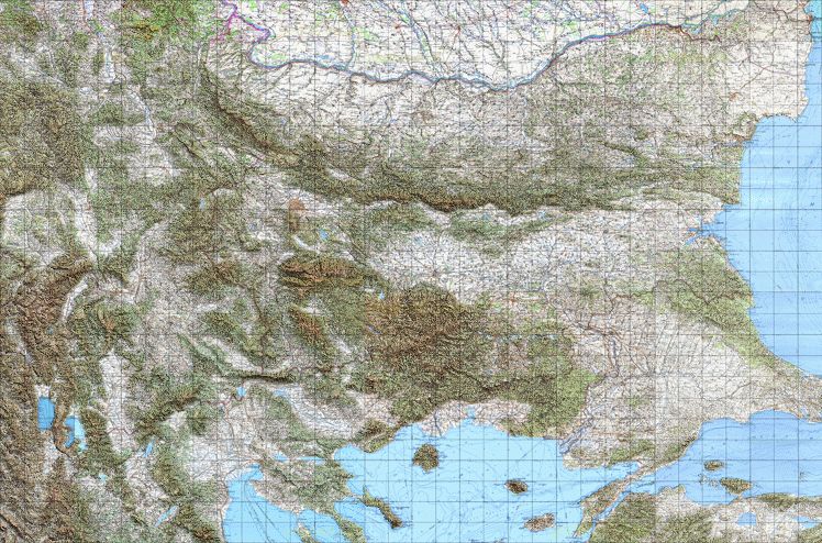
|
| 2.2 Garmin™ MapSource®/BaseCamp™ version |
HTTP • BitTorrent (Size: 7,544,367,234 bytes; MD5 hash: 484475119ded84e296cb46bfe047129b) Directions: At least 32 GB free hard disk space is required. Unzip the data (for example by 7-Zip) in a file system, which can be accessed by Garmin™ MapSource®/BaseCamp™, and then run install.bat |
| 2.3 Merged georeferenced raster with relief shading in ECW format |
HTTP • BitTorrent (Size: 5,631,236,976 bytes; MD5 hash: f82a5486ea442ed82f25136ee7c483b9; Projection: UTM, zone 35; Datum: WGS84; Digital Elevation Model: SRTM v4.1; Light source: azimuth 45°, altitude 60°) Requires Enhanced Compression Wavelet (ECW) format support. At least 6 GB free hard disk space is required. |
| 2.4 Merged georeferenced raster with relief shading in JNX format |
HTTP • BitTorrent (Size: 2,008,459,320 bytes; MD5 hash: febf5b981669505400b512b89d7587b2; Projection: Geographic; Datum: WGS84; Digital Elevation Model: SRTM v4.1; Light source: azimuth 45°, altitude 60°; JNX_PROD_ID: 100; JNX_VERSION: 4; JNX_ZORDER: 25; JNX_NUM_LEVELS: 1; JNX_LEVEL_SCALE: 4777; BIT DEPTH: 24; MAPS IN CATALOG: 17575) Suitable for newer Garmin™ GPSrs which support BirdsEye™ raster imagery, as well as for BaseCamp™ and QLankarte GT. At least 2 GB free hard disk space is required. |
| 2.5 MapNav version |
HTTP • BitTorrent (Size: 3,080,868,728 bytes; MD5 hash: b2c8765c78c66f793c7fd9b678abdcff; Projection: Mercator; Digital Elevation Model: SRTM v4.1; Light source: azimuth 45°, altitude 60°) Directions: At least 6 GB free hard disk space is required. Unzip the data (for example by 7-Zip) and load external (*.mno) or internal (*mnm) raster maps in MapNav at zoom levels 14, 15 or 16. |
| 2.6 OsmAnd / Locus Map version |
HTTP • BitTorrent (Size: 1,696,986,698 bytes; MD5 hash: 8401dff0985a56a492c3eb0dacc70e0b; Digital Elevation Model: SRTM v4.1; Light source: azimuth 45°, altitude 60°) Directions: At least 1.65 GB free hard disk space is required. Unzip the data (for example by 7-Zip) and copy the three resulting files in SD card/Android/data/net.osmand/files/tiles sub-folder of the OsmAnd application if your device is running Lollipop (for KitKat the corresponding folder location is SD card/osmand/tiles). Enable the OsmAnd "Online maps" plugin and select BGtopoVJ-osmand-z14-v3.00 as a map source. The map includes zoom levels from 6 to 14 and is displayed between scales 200 km and 200 m. This version is also compatible with Locus Map Free (the files should be placed in SD card/Locus/maps if your device runs KitKat). |
| 2.7 OruxMaps version |
HTTP • BitTorrent (Size: 2,257,774,527 bytes; MD5 hash: 80ccde5b7a7c1d78797fe04d756fcda1; Digital Elevation Model: SRTM v4.1; Light source: azimuth 45°, altitude 60°) Directions: At least 2.37 GB free hard disk space is required. Unzip the data (for example by 7-Zip), copy the BGtopoVJ-oruxmaps-v3.00 folder in the oruxmaps/mapfiles folder of the OruxMaps application and select it as a source. The map includes zoom levels from 6 to 14 and is displayed between scales 3000 km and 200 m. |
| 2.8 NaviComputer version |
HTTP • BitTorrent (Размер: 1,696,896,500 bytes; MD5 hash: 6a2f7fc7bb60342ac8cb6e13067a618a; Digital Elevation Model: SRTM v4.1; Light source: azimuth 45°, altitude 60°) Directions: At least 1.64 GB free hard disk space is required. Unzip the data (for example by 7-Zip) and copy the BGtopoVJ-navicomputer-v3.00.nmap file in the NaviComputer folder for offline maps in Microsoft's OneDrive service. Activate NaviComputer's Sync option and select the Import Offline Maps function. Select Offline maps to display BGtopoVJ. The map includes zoom levels from 6 to 14. |
| v3.00 (30.06.2011) |
|
| v2.01 (29.10.2010) |
|
| v2.00 (11.08.2009) |
|
| v1.10 (22.05.2009) |
|
| v1.01 (08.05.2009) |
|
| v1.00 (31.03.2009) |
|
| v0.02 (03.02.2009) |
|
| v0.01 (16.01.2009) |
|
| 4.1 Successfully tested Garmin™ GPSr devices |
|
| 4.2 Origin and type of data | Soviet army (1971-1991), scale 1:50000, raster TIF images (250 dpi, 8 bit depth), converted into Garmin™ GPSr compatible type and format |
| 4.3 Resolution | ~ 5.5 meters per pixel |
| 4.4 Total number of sheets | 544 |
| 4.5 Total number of tiles | 3240 |
| 4.6 Legend and abbreviations | Standard Soviet military topographic map legend and abbreviations are used. Further information is provided in Russian here. Detailed guide in Russian is available here. Another interesting source of information (in English) is the "Soviet Topographic Map Symbols" technical manual, published by the USA War Office, Headquarters, Department of the Army on June 12, 1958. |
| 4.7 Colour palette |
 32 colours, which have been found to fit best all 544 map sheets, as well as Garmin™ GPSmap 60CSx®'s colour palette |
| 4.8 Family ID (FID) | 20120 |
| 4.9 Product ID (PID) | 1 |
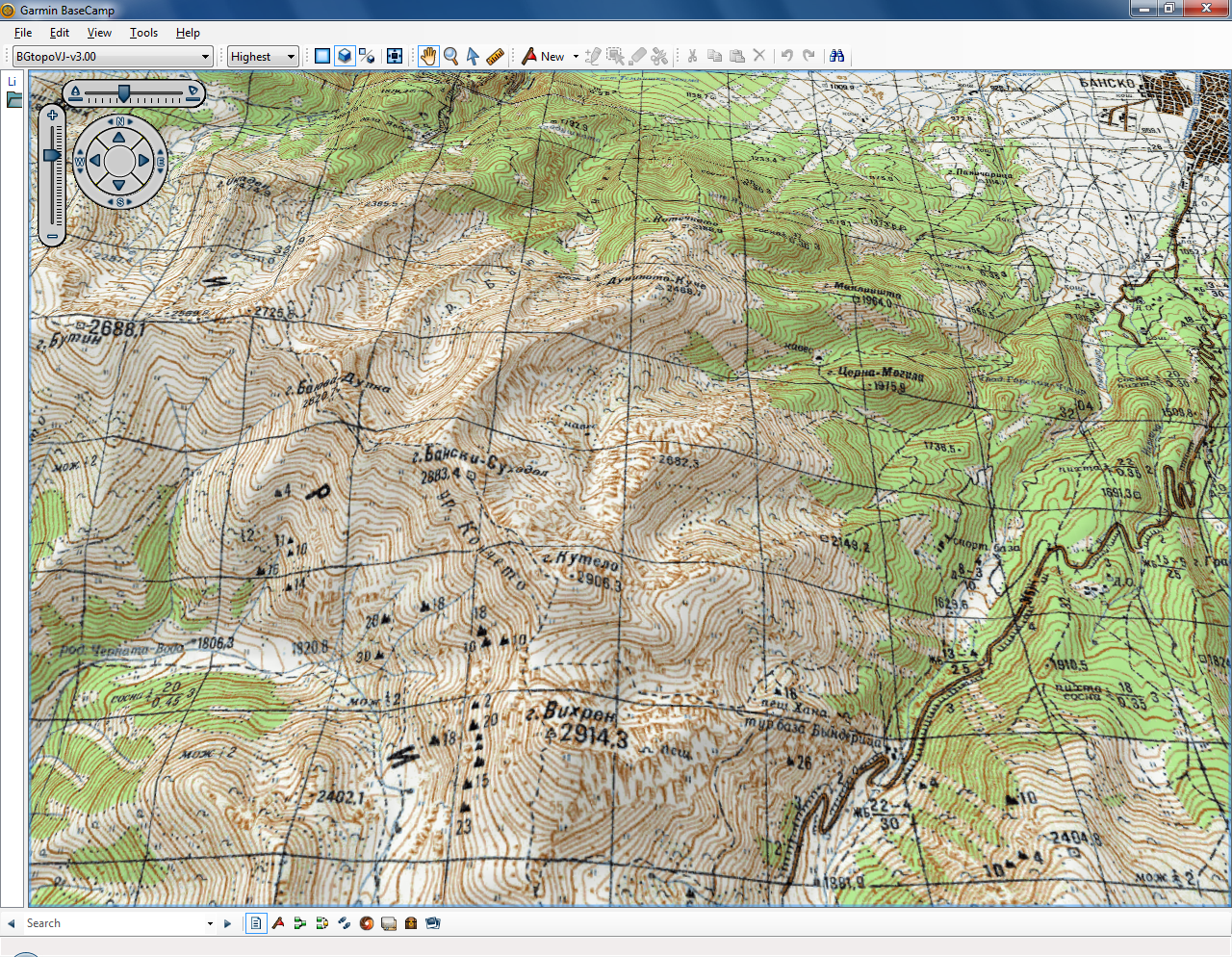
| 4.10 Screenshots |


")
")
")
")
|
| 4.11 Last modified | May 17, 2020 |
|
|
|
Credits go to: |
|
|
Please send your comments, suggestions or queries to Vedrin Jeliazkov. |
|
|
|
|
